
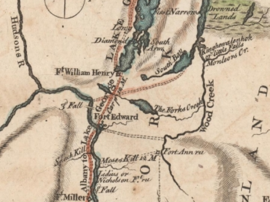
 In 1849 the Transactions of the New York State Agricultural Society reported that “Half-way brook… so named a century ago [in ca. 1749], as being equidistant between Fort Edward and Lake George.
“In [Washington County, it joins Wood Creek, which] is crossed by 10 bridges, that at Kane’s falls 70 feet long [a mile north of Fort Ann village], that at Fort Ann (covered) 50 feet long.
“At Patton’s mills [on Half-Way Brook, now memorialized by Patton Mills Road on the Kingsbury and Queensbury border] is a dam 12 feet high, with a grist and saw-mills.
“Tripoli dam [now the hamlet of Tripoli near the southern border of the Town of Fort Ann] of similar height has a grist, saw and shingle mills, carding machine and a trip hammer (for manufacturing anchors and sleigh shoes). Kane’s falls, 75 feet nearly perpendicular supply a grist and saw mills, machine shop and carding machine.
“The Padunk branch of Half-way brook is a mountain torrent, which at Anchorville [modern-day Podunk Road in southern Fort Ann] is occupied by a saw-mill, plaster-mill and clover-seed mill, carding machine, a large tannery and three forges and anchor shops with trip hammers.
“These last employ 50 men or more, making anchors up to 20 and 30 hundred weight, which are sent hence to New York and Buffalo.”
Settlement of Half-Way Brook
What follows is an excerpt from James Austin Holden’s “The Half-Way Brook in History” published in the Proceedings of the New York State Historical Association, Volume 6 (1906):
 Some time between 1759 and 1762, at the period following the conquest of Canada [during the French and Indian War (1754-1763)], General Jeffery Amherst granted a permit to one Geoffrey “Cooper,” or Cowper, as his name is spelled in Colonel Montresor’s Journal, to whom he was a sort of messenger or servant, to occupy the small post at “Half-Way Brook,” between Fort Edward and Lake George, for the preservation of the barracks, etc., that had been erected there, and for the convenience of travelers.
[Colonel James Montresor (1709–1776) served as the British Chief Engineer in America during the French and Indian War. The Montresor Journals, edited and annotated by G.D. Scull, was published in 1882 by the New York Historical Society.]
General Amherst, according to his dispatches, deemed it unnecessary after the reduction of Canada, to leave a garrison at that post. This Cowper was probably the first white inhabitant of the town of Queensbury.
According to tradition, he was originally a seafaring man. He resided here several years, and, in the town records, his name appears as having been elected to the office of Assessor at the first town meeting held 1766.
Hardly had the sounds of warfare died away, than the pioneer’s ax and saw were heard resounding among the yellow pines in this vicinity, as clearings were made and homesteads started.
In September, 1759, James DeLancey, Governor of the Colony of New York, issued a proclamation calling attention to the availability for settlers of “three Several Spotts of cleared Ground, two of them capable of containing half a dozen Families each and the other not less than twelve.”
 These clearings were located on the site of the picket forts at Green’s Bridge, where the Imperial Wall Paper Mill now stands [on Warren Street in Glens Falls], at the “Half-Way Brook,” which was the largest one [along what is now the east side of Route 9 in Queensbury], and near the Half-Way House [on west side of Route 9 at its intersection with Route 149], French Mountain (site of old Fort Williams).
[Fort Williams was one of a dozen small British military outposts established during the French and Indian War (1754–1763). The small stockade was built in 1759 near where Super Shoes currently stands.]
In response to this invitation to settle in the northern wilderness, on May 20, 1762, the Patent of Queensbury was granted to Daniel Prindle and others, consisting of a township of twenty-three thousand acres of land lying on the Hudson River and taking in the three clearings heretofore mentioned.
Part of this property was acquired by certain Quakers or Friends, living at the Oblong, in Dutchess County, New York.
On August 28, 1762, Abraham Wing, the founder of the town of Queensbury, accompanied by a surveyor, Zaccheus Towner, made his first visit to the place which was thereafter to become the scene of his life work. He stopped at the “Half-Way Brook” post with Jeffrey Cowper.
At this time “The Town Plot,” in the center of which the memorial marker now stands, was surveyed and laid out. This consisted of a plot of 44 ten-acre lots, six lots deep from north to south, and eight lots deep from east to west, forming an oblong square, intersected by central highways and necessary roads.
 The center lots being reserved for public buildings. Here, the village was to have been located, but it had been ordained otherwise. The settlement was made at “The Falls,” [Glens Falls] and nothing but the name in legal papers now survives to show that this was once intended to be the center of local population.
[A granite stone and bronze memorial tablet stand on Upper Bay Street on the bank of Halfway Brook within the historic Queensbury Quaker Burying Ground on Quaker Road.]
In 1763 the first attempt was made towards the permanent settlement of the Town of Queensbury; later on the first religious structure in the town, the original Friends’ church, was erected of logs on the lot standing on the southwesterly side of the “Half-Way Brook,” on the Bay road, and here, also, was located the first burial place in Queensbury.
(Here the founders and earliest settlers of the town were laid to rest, their place of sepulture being to-day unmarked and unknown.)
Commercial Development
Topographically, the “Half-Way Brook” in any State but New York, with its abundant streams and superior water power, would be entitled to and receive the appellation “River.” Owing to its size and the large territory which it traverses, it was in the early days of the country, of great service commercially in building up this section of the State.
Among the more important of the older enterprises on its banks was Forbes and Johnson’s Forge in 1811, for making plough-shares, situated on the Forge Pond, an expansion of the “Half-Way,” one and a half miles west of Glens Falls.
[The site sits roughly 1.5 miles west of downtown Glens Falls, immediately south of where Aviation Road crosses the brook, right where the popular Halfway Brook Trail begins near the Potter Road intersection.]
Jeremiah Briggs’ Grist and Saw Mills, at what is now the Brickyard, was frequented from far and near, in the early part of the century.
 [This site is slightly east of Upper Glen Street and just east of the Hovey Pond Park wetland. The clay beds dug out by the brickyard were later flooded and today Hovey Pond itself is the physical remnant of the brickyard’s clay excavations.]
[The brickyard was operated by the DeLong family (notably Zopher DeLong). The Glens Falls Brick Company heavily excavated in this area through the late 19th and early 20th centuries, producing up to 5 million bricks a year.]
Champlin’s Tannery near the south bank on the Lake George road [now the southwest corner of Upper Glen Street and Montray Road], and various saw mills, a woolen mill, and other manufacturies which were scattered all along the course of the brook and its tributaries, viz., Rocky Brook, the Meadow Run, what was then called “the Outlet” to the “Big Pond” (now Glen Lake), etc.
It was of even greater commercial importance in the towns of Kingsbury and Fort Ann, Washington County, than in Warren County. Here, sixty years ago, were located at Patten’s Mills, grist and saw mills; at Tripoli, grist and saw mills, a carding machine and trip hammer for making anchors and sleigh shoes; and at Kanes Falls, near Fort Ann, with a descent of seventy-five feet, saw and grist mills, a machine shop and carding machine.
On the Podunk branch of the “Half-Way” was located Anchorville, where there was a saw mill, plaster mill, clover seed mill, some carding machines, a large tannery, three forges and anchor shops. In later times there was situated at Kanes Falls a silex mill, also a woolen mill. The abundant water power at this place has in these latter days, been made use of by the Kanes Falls Pulp Company [1892-1904], for the manufacture of that commodity.
[A silex mills crushed quartz, flint, or silex rocks into fine powders used as wood fillers, abrasives, and paints.]
At the present time the principal business enterprises on the “Half-Way” in Warren County, are extensive brickyards, about a mile from the site of the old fort,three saw mills and two cider mills. In Washington County at Patten’s Mills, there is a grist mill, and at Griswolďs Mills [in the hamlet of Tripoli], a saw mill and a grist mill.
On the [Padunk] “branch” at West Fort Ann, is located a planer and cider mills. Owing to its width and the overflow of its banks in spring and fall, it is necessary that the brook be spanned by substantial bridges.
In both Warren and Washington Counties strong iron structures have replaced the old-fashioned wooden bridges, which were so common in road-making but a few years ago.
Read More About Half-Way Brook
This essay was lightly edited for clarity and annotated by John Warren.
Illustrations, from above: Detail from the map “The Country between Crown Point and Albany being the Great Pass from the English to the French Settlements in North America” (ca 1758) with Half Way brook shown as “The Forks Creek”; the original Fort Amherst Half-Way Brook Monument, since moved to Hovey Pond and installed on a new granite boulder; the former village of French Mountain in 1876 (corner of Route 9 and Route 149) showing the Half Way Brook House; a blockhouse and palisaded enclosure similar to what the station at Half Way Brook might have looked like; and a view of Half Way Brook, ca. 1904 (showing A-Site of Block House, B-Marker, C-Site of Fort Amherst).
Recent Comments