
 At least a dozen spots were fortified by British, Colonial and Native forces in what is now Warren County, NY for conflicts leading up to and including the French and Indian War (1754-1763). Those that survived those wars were reused by troops from both sides during the American Revolutionary War.
Of these dozen places, only one remains easily visible on the landscape – Fort George, at the southern end of Lake George.
The First Northern Forts
In 1709 (during Queen Anne’s War, 1702-1713), 1,500 British soldiers along with 600 Mohawk warriors, cut a road through the forest from Schuylerville (Old Saratoga) on the Hudson River, north to a fortified fur trading post (Fort Lydius, Fort Lyman) at what is now Fort Edward, and then following Wood Creek to Whitehall at the head of Lake Champlain.
 Three fortifications – Fort Saratoga (in Schuylerville), Fort Nicholson (Fort Edward) and Fort Anne and – were built along this road. All were square wooden structures with log palisades, and officer barracks in the corners.
These forts have been described as “constructed wholly of timber and were similar to the other stockade fortifications of the country at that period – affording an effectual defence against any attack of musketry, but incapable of withstanding artillery.”
Fort Nicholson (Fort Lydius from 1744-1748 and Fort Edward after 1754) was built on the west side of Hudson River at the start of the Great Carrying Place where a fortified trading post had stood. A contemporary visitor described Fort Nicholson as “not so much a fort, as a magazine to Fort Anne” and Fort Anne “built in the same manner as the forts Saratoga and Nicholson.”
 Fort Anne, the northernmost of these fortified areas was built on the west side of Wood Creek. A description of Fort Anne in 1776 indicated that it was a simple picket fort without ditch or earth embankment.
It was square and enclosed approximately half an acre’s space which was manned by a garrison of between 50 to 100 men. The fort contained a single wooden clapboard barracks, one story high, sixteen feet wide and thirty or forty feet long.
Fort Miller was likely the most substantial of the northern forts built in the early 1700s. Located at the second Carrying Place on the west side of the Hudson River, it was built in 1711 with storehouses built:
“upon the flat on the west side of the river at the head of the falls. This flat is protected upon three of its sides by the river, which curves around it in a form to that of a horse shoe. About one-third of the remaining side is covered by a lagune or narrow bay which makes off from the river.”
![]()
![]() A timber and earth covered parapet with a “deep fosse” (a deep ditch or moat) in front was located on the flats, and extended from the bay to the river. It held a blockhouse and was considered the “strongest position of any of the carrying-places along the river” by at least one observer.
A timber and earth covered parapet with a “deep fosse” (a deep ditch or moat) in front was located on the flats, and extended from the bay to the river. It held a blockhouse and was considered the “strongest position of any of the carrying-places along the river” by at least one observer.
By the time of King George’s War (1744–1748), it was reported that Fort Anne and Fort Nicholson were quite dilapidated, and though the government was urged repeatedly to fix them, they were allowed to fall into further disrepair.
During King George’s War the French focused attacks on the Schuyler plantation, and the settlements nearby, and at Fort Saratoga/Fort Clinton. During the 1745 “First Battle of Saratoga” 500 French and Indigenous allies from Fort St. Frederic (at Crown Point) attacked the village, burning 30 houses, several mills, and the fort as well as killing, scalping, and capturing soldiers and residents, including several enslaved people.
Ten years later, at the time of the French and Indian War (1754-1763), the British and their American allies began improving already established way stations and building more substantial fortifications.
These would be located north of Fort Edward and west of Fort Anne, along a more direct route from Fort Edward to Lake George cut by William Johnson‘s men in 1755.
Four Mile & Seven Mile Posts
In 1759 a stockade fort was constructed by the British near where today’s Shermantown Road crosses the Glens Falls Feeder Canal to serve as a strategic defense and supply point and could hold around 300 men.
The post was one of a chain of fortified supply and communication points between the two most important British forts: Fort Edward on the Hudson River and Fort William Henry/Fort George at the head of Lake George.
Four Mile Post was four miles north of Fort Edward; Half Way Brook post (or Seven Mile Post), was Seven Miles North of Fort Edward, or about halfway along William Johnson’s 14-mile 1755 military road directly to Lake George.
The fortified area was just south of Blind Rock, a boundary marker’s assumed by New France to be the edge of their territory. Used as a watering hole even earlier, it was occupied by 800 men and more formally developed after Johnson’s defeat of the French at the Siege of Lake George in 1755.
 At Seven Mile Post there was a blockhouse with a stockaded enclosure just south of what is now Glenwood Avenue in Queensbury. Two additional blockhouses were build nearby (where the Queensbury Price Chopper now stands) in 1756.
The other block house was built by the British in 1758 after an inspection tour by Col. James Montressor, the senior British engineering officer; this one stood where Baker Funeral Home is located. The so called “Garrison Ground” was an cantonment on the south bank of the Halfway Brook near the block houses, that was occupied by Lord Howe and 3,000 men en route to the disastrous Battle of Fort Carillon in 1758.
This area was also known as Halfway Brook Post, and was partially laid out in 1757 by Montresor and completed in 1758. It was occupied by British Major Robert Rogers and his group of 358 troops in March 1759.
Between 1759 and 1762, the post was occupied by Geoffrey Cowper, under the command of British General Jeffery Amherst to preserve the barracks and other buildings. After the conquest of Canada, Amherst deemed it unnecessary to leave a garrison at the fort. Half-Way Brook Post once stood where Mavis Discount Tire Store and Firestone Complete Auto Care now stand.
Fort Amherst was built by the British along the Halfway Brook at the Garrison Grounds in 1759. It once stood southeast of what is now Glenwood Avenue. A plaque at the location, now in Hovey Pond Park, reads:
“From 1755 to 1780 it was the scene of many bloody skirmishes, surprises and ambushes. Here the French and Indians inflicted two horrible massacres upon the English and Colonials. One in the summer of 1756 and the other in July, 1758.”
 The Northern Forts At Lake George
Heading north from Halfway Brook / Fort Amherst the next outpost was about half-way to the end of Lake George at what is now the Lake George Outlets. “Three Mile Fort” was a palisaded enclosure built by the British in 1759.
It was located in the woods East of the Adirondack Outlet Mall, behind Starbucks. A second stockade fort, Fort Williams, was built nearby around the same time, near where Super Shoes currently is.
Fort Gage, was another more temporary stockaded enclosure occupied by Amherst and Thomas Gage as they moved the main British Army to the ill-fated attack on Fort Carillon in 1758. It once stood behind the former Ramada Inn at exit 21 on I-87.
At the south end of lake George (technically the head of the lake which flows north to Ticonderoga), Fort William Henry was ordered built by Sir William Johnson in September 1755.
Located in an area disputed between the British, French and Iroquois, it served as a staging ground for attacks against French Fort St. Frédéric at Crown Point and could house 400 to 500 men.
Fort William Henry was destroyed in 1757 following the a successful siege by French forces. Today, a recreated fort sits on the grounds of the former fort.
To replace Fort William Henry, in June 1759 Amherst arrived at Lake George and proceeded to build a new fort on the high ground east of the ruins of Fort William Henry. A provincial officer described the fort as “the walls [are] about 14 feet thick built of stone and lime.”
In 1760, Amherst said of Fort George: “The bastion enclosed at Fort George is very neat, mounts 15 guns, is very small and a bad defense, but ’twas the shortest, cheapest, and best method of finishing what was begun at the Fort.”
This bastion was the only part of the planned fort that was finished. It’s remains are located at the Lake George Battlefield State Park.
This essay is based on a poster produced by Patrick Eppedico-Cirillo and other Scouts of Troop 6016 as an Eagle Scout Service Project. John Warren also contributed.
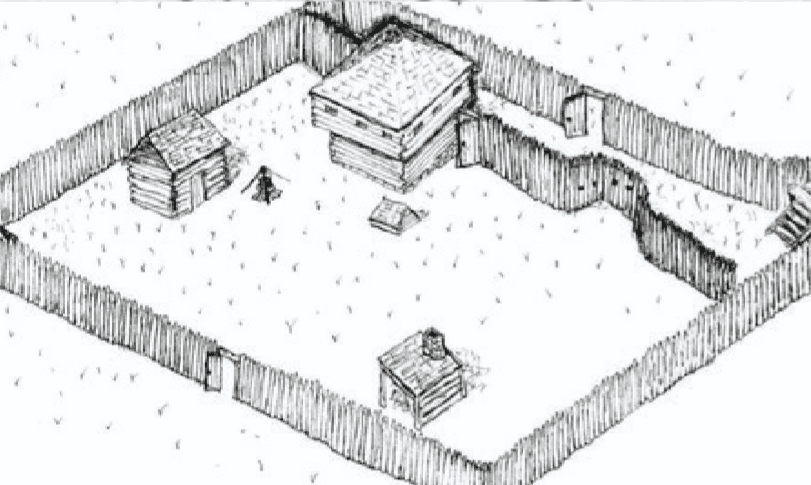
Illustrations, from above: A blockhouse and palisaded enclosure similar to some of these fortification might have looked like; French map Chemin des Iroquois (Jean Bourdon ca. 1646) during King George’s War; map showing Fort Anne, Fort Edward and its relation to Lake George and Fort William Henry and Fort George; Map of British and French fortifications during King George’s War (Hartgen, 2004); a recreated palisaded stockade wall at Johnson Hall like the one installed at Four Mile Post (courtesy State Parks); and French and Indian Wars Forts in Hudson Champlain and Lake George corridor (Warfare History Network).
Recent Comments